After more than 10 years research on the AQM-34, I realised that I had only the vaguest idea of what an actual mission looked like. Together with Craig Kaston I started looking into the available data, in order to produce some first estimates. I chose the AQM-34L (Model 147SC) and its missions as the first subject of the studies. 'Lightning Bugs and other reconnaissance drones' by William Wagner contained some snippets on missions, that are listed below. The performance data of the BQM-34A target drone was analysed and roughly recalculated for the heavier AQM-34. All in all it is a lot of guessing, but maybe this page triggers the memories of those involved, or better ideas how to approach the subject. See also the Blue Springs missions page.
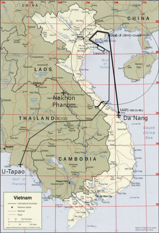
The flight tracks below are plotted on a map found in the University of Texas Library - Perry-Castañeda Library Map Collection, to which were added clearer and more latitude/longitude grid lines, plus airfield names. Distance between the 2 degree longitude (vertical) lines is 113 nautical miles / 209 kilometers, at the 20 degree latitude. Distance between the 2 degree latitude (horizontal) lines is 120 miles / 222 kilometers.
The large circle in each chart represents the 200 mile limit of the APW-23 'Airborne Microwave Command Guidance System' (MCGS) radar set of the DC-130, that was used to monitor the flight path of the AQM-34 and if necessary give steering commands. See 'The 99th Strategic Reconnaissance Squadron' by Steve Miller, pages 342, 390, 443, 472 and others.

| Guesstimated flight track 1: U-Tapao take-off, via Thailand and Laos to South-Vietnam, crossing south of DMZ to South China Sea / Gulf of Tonkin. Holding pattern and launch off the coast of Haiphong, turning north for a short 140 nm low-level leg, then 320 nm climb-cruise. MARS recovery near Da Nang. |
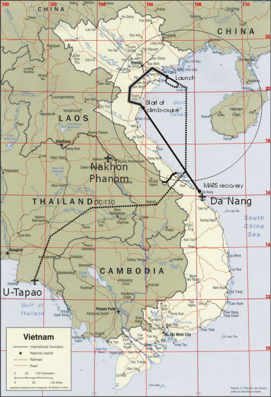
| Guesstimated flight track 2: Haiphong launch, turning south for a slightly longer 160 nm low-level leg, then 240 nm climb-cruise. MARS recovery near Da Nang. |
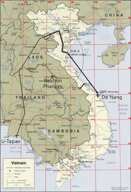
| Guesstimated flight track 3: U-Tapao take-off, via Thailand and Laos towards North Vietnam. Holding pattern and launch just outside North Vietnam, west of Hanoi. To Hanoi, then turning south for 160 nm low-level leg, then 240 nm climb-cruise. MARS recovery near Da Nang. |
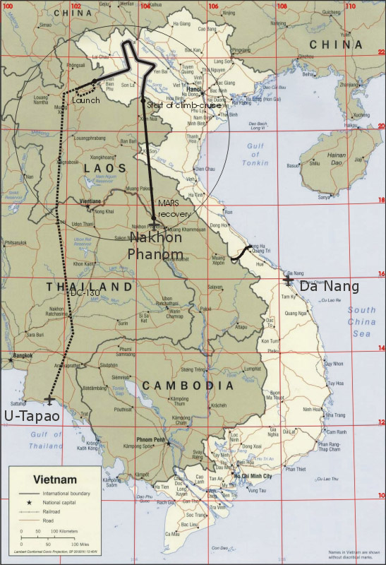
| Guesstimated flight track 4: U-Tapao take-off, via Thailand and Laos towards North Vietnam. Holding pattern and launch just outside North Vietnam. Several photo targets in the north-west corner of North Vietnam, 200 nm total. Exit of NV, 205 nm climb-cruise towards Nakhon Phanom. MARS recovery near Da Nang. |
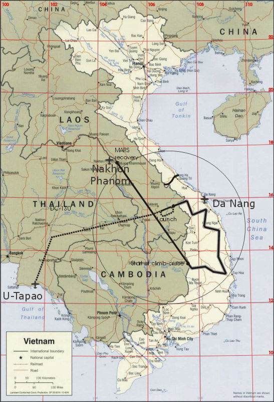
| Guesstimated flight track 5: U-Tapao take-off, via Thailand and Laos towards South Vietnam. Holding pattern and launch near South Vietnam border. Several photo targets south of Da Nang in South Vietnam area occupied by North Vietnam troops, 295 nm. Exit of SV, 305 nm climb-cruise towards Nakhon Phanom. MARS recovery near Nakhon Phanom. This mission is likely too long for an AQM-34L. Possibly an AQM-34M with drop tanks could make it. |
DC-130 track:
no information, randomly picked waypoints
Launch:
altitude 3000 ft
DC-130 speed unknown
Firebee speed:
500 knots assumed
Range estimates for different flight profiles:
lo-lo: 375 nm low level. Might be theoretical since it excludes MARS recovery
lo-hi: 200 nm low level + 250 nm cruise climb to 52,000 ft, 450 nm total
lo-hi: 150 nm low level + 350 nm cruise climb to 52,000 ft, 500 nm total
hi-hi: 650 nm. Might be theoretical since the camera does not function properly at height. 1160 nm is calculated below from BQM-34A 'Standard Aircraft Characteristics' (PDF) Mission A
Waypoints:
no idea of the actual number. Three or four assumed
possibly the tracks were more detailed
Photo targets:
no idea of the actual number. Three or four assumed
random areas and lengths picked
Recovery
arrival at recovery area at 52,000 ft. Engine stopped, drogue chute pulled
I would guess that a Firebee has a useful glide range. Assuming a glide from 52,000 to 15,000 ft, using a glide ratio 8 (which might be optimistic), I calculate 49 nautical miles. Possibly battery capacity is critical here?
main chute pulled at 15,000 feet
MARS pickup at 10,000 ft
The following collection of snippets gives a rough idea of how the programmer worked.
p56: "The 147B had the Ryan Doppler system so the flight events were programmed at seven mile intervals based on ground distance measurement that came from the pulses generated by the Doppler signals. The backup program, as in the early birds, was based strictly on time so that in the mission planning you had to include wind compensation and everything else which goes into dead-reckoning. "
p56: "The snafu, it later turned out, was a short in the programmer. Consequently at the end of the mission, when the radio and beacon, telemetry and other systems were scheduled to come back on, they didn't. The birds were built so they could not be recovered except by command. So when the radio command didn't come back up on the program, it was goodby bird! "
p62: "At around 4:00 a.m. one programmer went up in smoke while it was being stepped through and checked. A malfunction caused the programmer to stop operation at pulse 70 or 80"
p108: "The basic principle is to deploy chutes at medium altitude - somewhere around 15,00 feet. The retrieval helicopter is some 3,000 feet lower."
p191: "Flying at 1000 to 1200 feet altitude in a very hostile atmosphere the drones were taking unacceptable losses. To counter the concentrated firepower, mission profiles were changed so that after launch at 3000 feet the S birds were flown down to 500 feet above enemy terrain at 500 knots."
p192: "A check of flight records for the recce drones during November operations reportedly shows 19 sorties flown, and all birds recovered. None appear to have been scheduled for flights as far north as Hanoi. Two missions on the 20th and 21st were cancelled because of weather. Whether or not they were scheduled to have been routed over Son Tay is not clear. On other occasions, however, the drones did bring back good photos of the downtown 'Hanoi Hilton.' "
p194: "The drones have been operating in areas that are normally denied to manned reconnaissance airplanes because of the high threat environment. Routes typically covered are Haiphong and Hanoi; in fact all of North Vietnam and even some flights over South Vietnam in areas that are now occupied by the North Vietnamese Army."
p194: "The drone flights are usually launched over the Gulf of Tonkin and occasionally from Northern Laos, but I'd say at least 90% are from the Gulf of Tonkin."
p194: "These low altitude Buffalo Hunter missions are usually flown between 500 and 800 feet. This is where the drone brings back the best technical intelligence. The SC doesn't have the added navigational capability that the SD does. It has to be updated by remote control on occasions to be sure that the targets are covered. But with the deployment of the SD sometime in June they will have a system that will be much more accurate; not only the basic nav system in the SD but there will be a Loran capability also that will provide accuracies up to ± 200-250 feet."
p195: "There have been many missions flown over Haiphong. I don't know if they were specifically to count the number of ships in the harbor or to survey bomb damage in the Haiphong area."
p195: "The low-level 147SCs, he reported, frequently went in far deeper northwest of Hanoi than ever before, requiring terminating the flights much farther north in the Gulf of Tonkin. On those occasions, the Air Force arranged to have the Navy pick up the birds; then the Air Force would pick up the birds; then the Air Force would immediately fly the intelligence 'take' back for processing and interpretation."
p195: "Also, the SCs were capable of being routed so as to obtain information on a number of targets, reducing the requirement for going after just a single target."
p195: "Monitoring shipping activities, or rather the lack of activity, in Haiphong Harbor was a special concern of the 100th Strategic Reconnaissance Wing's 'Buffalo Hunter' missions during May."
Another collection of snippets from an authoritative source:
page xi: project names 'Blue Spring', 'Bumble Bug', 'Bumpy Action' and 'Buffalo Hunter'
page 0: photo of AQM-34L L-234
page 2: Model 147SC was designed for use in the altitude range of 500 to 1,500 feet.
page 3:
nominal speed 500-540 kts
maximum speed 590 kts at sea level
edit: from these two facts we can calculate that 500 knots requires a 72% power setting, or less due to Mach effects. For 530 knots this figure is 81%, and this is the same as the ratio between the J69T-29's max rating (1700 lbf static) and the normal rating (1375 lbf static) of 81%. I conclude that the low-level leg was flown at the normal rating, and therefore with a fuel flow of 3.83 gallons/min. See calculation below.
max range ~650 nautical miles
1800 feet of 70 mm film
120 nautical miles of continuous photography
lateral coverage 3 nautical miles at 1500 ft altitude
lateral coverage 1-2 nautical miles at 500 ft altitude
maximum altitude for camera: 3750 feet
page 4:
3% navigation error CEP 50%
correction possible by MCGS
page 6:
typically 5 to 15 photo targets
low-level (camera on) track usually covered 160 nautical miles. Does this contradict the 120 nautical miles on page 3?
climb started immediately following photo profile
climb to 45,000 feet
followed by cruise climb to 52,000 feet
a low drone flight typically covered 430 nautical miles
page 7: launch typicaly at 2000 feet
page 9: MCGS corrections only done when track deviation >2-5 nautical miles
page 10:
climb immediately following photo profile
handover from DC-130 / ARCO to Drone Recovery Officer (DRO) at 75-150 nautical miles from MARS area
drag chute pulled at 52,000 feet
main chute pulled at 15,000 feet
MARS engagement at 10,000 feet
page 11: movements of Buffalo Hunter units
page 14: catalog with 109 pre-programmed tracks for the southern panhandle of North Vietnam existed
page 15: "it was easier to change a complete mission than to change a target or heading after the drone was programed."
page 15: "low altitude reconnaissance in southern Laos" was apparently also performed
page 16: "there were only two DC-130s at U-Tapao, so the two drones per day sortie rate and last minute changes that 7AF requested could not always be achieved within crew rest requirements"
page 18: "Each mission was planned in its entirety even though the track mignt have been flown before."
page 18: "Ideally, a low drone should pass directly over each target in straight and level flight at 500 to 1,500 feet and at a speed to provide 50 to 60 percent overlap of consecutive film frames. The overlap allowed the 12th RITS photo interpreters to view targets using consecutive frames and stereoscopic optics. Fifty to 60 percent overlap was optimum but 30 percent was acceptable. When straight and level flight over the target was impossible because of terrain features, the track planners programmed the drone to cross the target at the desired altitude, but during climb or descent modes."
page 19: "To allow for the 3 percent error in the navigation system, the SRC planned the low drone profiles to clear all terrain within 5 NM of the track by at least 500 feet. At the same time, the planners made use of topographical features to achieve surprise and to reduce the enemy's reaction time."
page 19: "Weather was a primal consideration for two reasons: (1) the programmed drone altitudes were based on a forecast altimeter setting for the target area, and (2) the desired drone profile was approximately 500 feet below any cloud deck in excess of three-eights coverage."
page 20: "Operational experience had taught the route planners that a low, fast mission profile increased the drones' survivability against enemy defenses."
page 20: "If the weather was bad below 2,500 feet, there was no MIG threat, and below 700 feet there was little SAM threat. When a mission profile would place a drone above 700 feet in a SAM envelope, the LCOs programmed the drone to change headings, £altitude, or airspeed -- or a combination of these -- every 4O seconds."
page 20: "On the other hand, if the MIGs came up during clear weather, there was no SAM threat because the enemy would not fire SAMs or AAA near the MIGs. The ARCOs were not permitted to give the drones evasive commands to degrade SAM or AAA threats, only to evade the MIGs."
page 21: "When advised of a MIG threat by 'Red Crown' (a radar-equipped U.S. Navy destroyer on station in the northern part of the Gulf of Tonkin), by U.S. electronic warfare support aircraft, or by other U.S. aircraft near a drone, the ARCOs put the drone through jinking maneuvers to degrade the threat. These maneuvers combined with the drone's small profile and lack of a smoke trail apparently made it a difficult target for the MIGs. Few drones were downed by MIGs, but that could also have been due to lack of interest: the drones were passive and much less lucrative targets than manned strike aircraft."
page 21: "Overall, the drones fared rather well in the enemy air defense environment. Of the 292 drones launched for overflight of North Vietnam in 1970, only nine were confirmed lost due to enemy action--five to SAM, three to MIGs, and one to AAA. An additional five drones were lost to unknown causes, possibly enemy action. In 1971, six drones out of 286 launched were lost to the enemy and eight for unknown reasons. Total losses for all reasons (mechanical failure, operational error, guidance system failure, enemy defenses, etc.) were 39 in 1970 and 30 in 1971. The losses attributed to enemy defenses were not available for 1972, but through November the total lost for all reasons was 44. Of that number, seven returned but were not recovered."
page 24: "In May 1970, EB-66s of the 42d Tactical Electronic Warfare Squadron and EA-6s of the lst Marine Air Wing were providing about 75 ECM sorties per month in support of 30 Buffalo Hunter sorties. Normally, the same ECM sorties were also serving other air operations at the same time, thus the drone missions only received partial ECM support. According to a Headquarters PACAF study, SAC requested ECM support for 198 Buffalo Hunter missions during FY 1971, but the support was provided for only 98."
page 25: "For a low altitude drone, ECM support will normally be of little assistance against MIG or AAA threats because ECM effectiveness against Barlock GCI [Ground Controlled Intercept] radar is minimal, and the AAA threat at low altitude is predominately visually controlled."
page 25: "Various causes other than enemy defenses accounted for most drone losses: guidance system and engine malfunctions accounted for some, some were lost at recovery because the recovery parachute did not deploy properly, or the drone sank before or during water recovery. Many times drones went down for no apparent reason. Such losses were possibly the result of enemy action, but more likely a guidance system malfunction or a mechanical failure was responsible. Some of the confirmed losses occurred following drone malfunctions which rendered the drones vulnerable to enemy defenses."
page 26: "In one case, the enemy defenses were not the only military threat to the drone. According to one drone operations officer at the 99th SRS, a DRO controlling a drone on its egreee from North Vietnam monitored two U.S. Navy pilots giving a MIG warning. It was a few seconds before he realized from their radio transmissions that the friendly pilots were after his drone. Since he could not transmit directly to the Navy aircraft, he hurriedly radioed the DC-130 mother ship to call the pilots off--but too late. Despite the DRO's efforts to evade them, the Navy aircraft confirmed the drone as a MIG and downed it."
page 26:"After planning a drone's track, the SRC transmitted the route message to the drone operations personnel in SEA. The LCOs and the ARCO plotted the track on their charts in preparation for the mission and carefully checked the SRC route for any requirements outside the drone's capabilities. This done, they transmitted a track confirmation back to the SRC and programmed the drone for the track. SAC transmitted mission plans to the reconnaissance users and track warnings to combat units operating in the vicinity of the drones."
page 27: "As the SRC track planners gained experience, drone survivability increased. Prior to Buffalo Hunter, drones averaged about four sorties before being lost. In 1970, however, they averaged 7.5 sorties and their lifetime increased to 9.5 sorties in 1971, then to 9.6 in 1972. In addition to effecting a reduction in operating costs, the longer lifetimes meant that less intelligence information would be forfeited because of lost drones."
page 30: "From the beginning of the Buffalo Hunter program the low altitude drone was the primary vehicle. Originally the planned sortie rate was approximately 25 per month for the low drones compared to one or two for the high altitude drones."
page 31: "The low drones were on target about 40 percent of the time. For example, in 1972 the low drones successfully covered 2,543 of the 6,335 high priority targets they attempted. The success rate was 38 percent in 1970 and 40 percent in 1971."
page 33: "The Buffalo Hunter sortie rate began at about 25 per month in February 1970 and remained at that rate until 1972 when it began to average about 40 sorties per month. In December 1972, the DC-130 crews launched a record 78 drones in support of the U.S. reconnaissance effort just prior to LINEBACKER II and then in support of that campaign. The old monthly record of 47 launches was already surpassed at Christmas; the two DC-130s had been launching four drones per day for most of the month. After Christmas, a third DC-130 participated in drone launch operations."
Craig Kaston reports:
As I minimally understand it, the early 1960-vintage patchboard programmer had about 40 commands including turns. Dual commands could be enabled by using a 'Y' jumper (two commands at the same pulse). There were no waypoints in the modern sense. It was all dead reckoning based on the mission planning, weather (winds aloft), plus distance flown and crosstrack correction generated by the Model 523 Doppler Radar Navigator. The 523 would issue one pulse to the programmer for every seven miles traveled. Egress commands could notionally look like:
pulse 27 scorer off (27 * 7 is about 189 nautical miles downrange in our hypothetical flight)
pulse 28 turn to 160 degrees
pulse 28 increase thrust
pulse 29 climb
pulse 35 straight and level
pulse 35 decrease thrust
pulse 50 MCGS to 'ON' (RPV can now receive external commands, is remotely controllable and is off the internal programmer) (50 * 7 is about 350 miles flown from launch point)
Crosstrack correction was probably fed directly to the flight control box. By the time you got into the 147SDL with the solid state computer and LORAN, things changed greatly for now you now had closed loop guidance with correction (to the limits of LORAN).
As a side note, in one photo made at the People's Air Force Museum & Air Defense Museum, Hanoi, the remains of a mechanical programmer can be seen.
147SC mass
max launch weight 3065 lbs
Fuel
100 gallons in BQM-34A + 68 gallons in rear fuselage extension (Wagner p26), total 168 gallons
JP-4 density 750-802 kg/m3 or 6.5 lb/gallon
JP-5 density 788-845 kg/m3
J69T-29
max rating 1700 lbf static (30 min), SFC 1.10 (Jane's)
normal rating 1375 lbf static (30 min), SFC 1.085 (Jane's)
BQM-34A 'Standard Aircraft Characteristics' (PDF), analysis of 'Mission F' which is 610 knots at low level and hence most like that of the AQM-34L.
engine at max rating = mil rating: 1700 lbf static (30 min), SFC 1.10 (Jane's), fuel consumption 1870 lbs/hr or 288 gallons/hr or 4.80 gallons/min
engine at normal rating: 1375 lbf static (30 min), SFC 1.085 (Jane's), fuel consumption 1492 lbs/hr or 230 gallons/hr or 3.83 gallons/min
Mission F includes 4 minutes of mil power on the pylon (warm up and range free wait). 4 minutes consumes 19.2 gallons. 100-19.2 = 80.8 gallons left. Usable fuel could be even less?
Since the fuel left is 80.8 gallons, 0.281 hrs = 16.8 min running time at mil rating remains. Theoretically, for full fuel, 0.347 hours = 20.8 minutes
Two ranges are quoted for Mission F, 137 and 156 nm. The average is 147 nm, and this gives a flight time of 147/610 = 0.241 hours = 14.5 minutes. 2.3 minutes less than calculated above, unexplained
BQM-34A at 500 knots at low level
If speed is reduced from 610 to 500 knots, drag is expected in the order of (500/610)^2 = 0.67 times, ignoring Mach effects, which would make the reduction greater. If drag is 67%, required thrust is also 67%, and fuel consumption also 67% if constant SFC is assumed, therefore 1253 lbs/hr or 193 gallons/hr or 3.21 gallons/min
For full fuel, this would give 100/193 = 0.516 hr = 31.0 min, giving a range of 0.516 * 500 = 258 nm
AQM-34L at 500 knots at low level
If it is assume that the 147SC has 1.68 times the fuel, that it is topped off completely before launch, and assuming the BQM-34A drag model, the lo-lo range becomes 1.68*258 = 433 nm. Since the AQM-34L is heavier thus will have extra induced drag, plus a bit more skin drag, actual range is likely be below 400 nm. The 375 nm figure quoted above for a lo-lo mission seems reasonable.
AQM-34L at 500 knots at high level
If the BQM-34A range for 'Mission A' from the BQM-34A 'Standard Aircraft Characteristics' (PDF) is simply multiplied by 1.68 as above, and then reduced by a guesstimated 15% for the higher mass, 1160 nm is calculated.
The BQM-34A polar (including Mach effects) could be derived from data and graphs in the Standard Aircraft Characteristic sheet. The polar could then be modified for the AQM-34. A J69 thrust model is also required, including density and speed effects. See for example: 'Theory and Practice of Aircraft Performance' by Ajoy Kumar Kundu, Mark A. Price, David Riordan. Or seach on "polar high subsonic aircraft"