Mystery Luftwaffe hangar skeleton at Volkel airbase
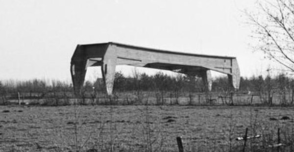
I grew up near Volkel airbase, that was built by the Germans in 1940. Little remains of that time, but as most residents of Uden, Volkel and Zeeland over age 45 will know, a strange wartime object resides next to the Zeelandsedijk, just outside the airbase fence. It was often rumoured to be a V1 launch rail. Younger residents will generally not know it, because the airbase fence was moved to include the object, and a treeline was grown to hide it (mostly) from view.
I still do not know exactly what this structure is. In 2021, I decided to launch the question on the BritModeller scale models forum. This page shows an extensive summary of that thread, with new information added. However, despite the forum thread and all subsequent research, no real answer was found so far.
|
1947 photo
A RNLAF photo from around 1947 shows the debris of all destroyed German infrastructure had been cleaned up, but with the skeletons of two T-hangars still standing. In the lower left is the subject of this page, in the upper right a similar structure, but with less damage. The roof is flat instead of concave. The buildings in the middle are post-war.
The road at the bottom of the photo is the Zeelandsedijk, that connects the villages of Zeeland and Volkel. The base gate is at the bottom right.
| 
|
1949 photos
I found a set of three photos taken in February 1949. It looks like they were made on the Zeelandsedijk, seen from the north. The slight tilt makes it look like a starting ramp of 'something'.
The landscape looks amazingly bare, compared to the current time.
The location is 51°39'33.39"N 5°40'27.63"E.
| 
|
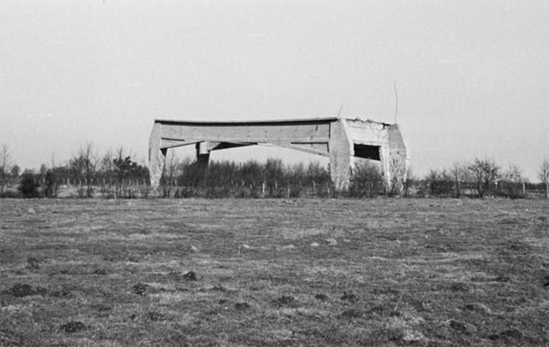
| Seen from the west, again from the Zeelandsedijk. Rebar appears to be projecting from both south corners of the stucture. The upper surface looks slighty concave, but that could be the result of damage. The height of concrete beams suggests that expected force acting from top was much more than just a roof.
|
| Seen from the south. The base fence can be seen behind it. The base was a marines training camp at the time, not a RNLAF air base yet.
| 
|
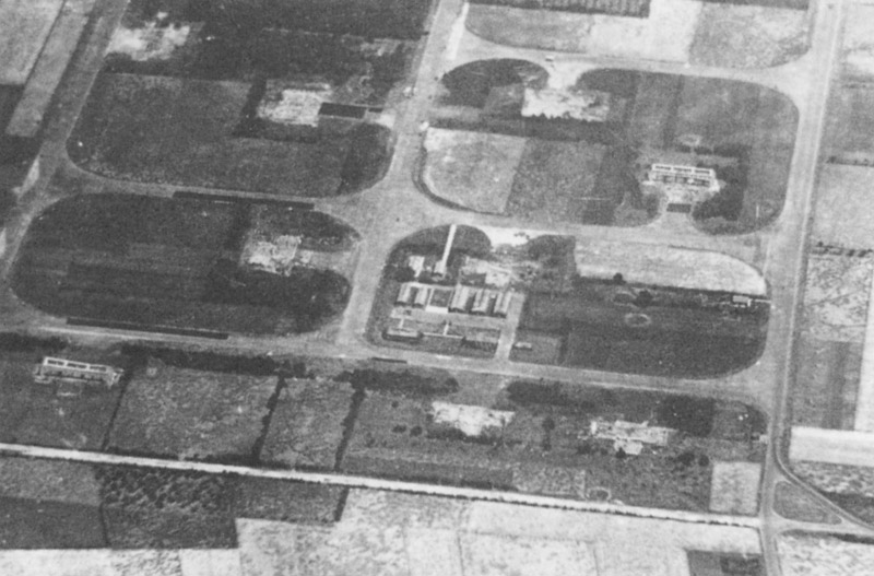
1951 photo
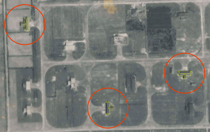
In this aerial photo dated 9 October 1951, the two hangar skeletons are still present, as in the 1947 photo. The one discussed here is circled in red, the other one in green. More information below.
Source: Nederlands Instituut voor Militaire Historie
| 
|
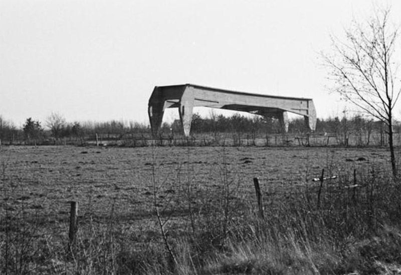
~1980 photos
I found two more historic photos, undated. The black and white photography suggests pre-1980. Here the skeleton is seen from the side of the base. The low fence suggests that the main fence was moved outwards to include the object.
Source: Nederlands Instituut voor Militaire Historie
| 
|
~2015 photo
The situation has changed here: trees have been grown on three sides, making the hangar skeleton mostly invisible from the public road. The base commander (B. Droste) did not like having this 'wreck' on his airbase, but it was listed as a municipal monument (plus considered for a national monument) and could not be torn down.
As an alternative solution, the fence was moved towards the public road. The extra space allowed the construction of a perimeter road inside the fence, so patrols could continuously check the fence, because peace activists were very active. Trees were planted between the skeleton and the road.
The structure is still visible: when driving on the Zeelandsedijk, take the short road just north of the structure, that leads to a unused gate of the air base ('poort Noordeinde'). There's a picknick bench and a sign explaining the thing.
Source: Spotting Group Volkel: Historisch basisbezoek
| 
|
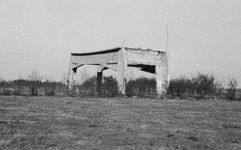
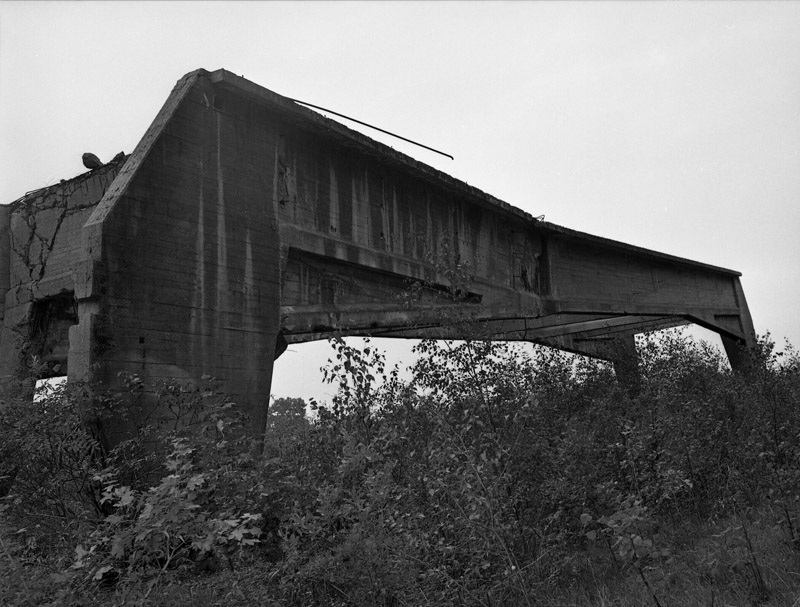
2016 detail photos
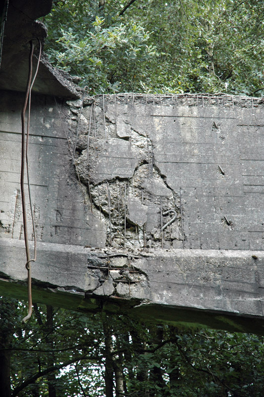
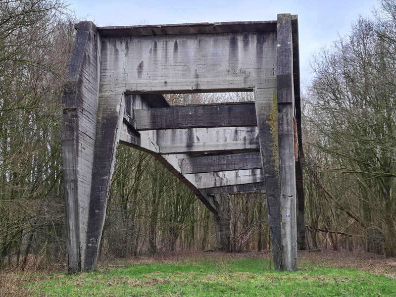
| In 2016, I joined a 'historic base visit' by Spotting Group Volkel, and the tour included the skeleton. This photo shows lots of rebar in the top beam. But there's very little rebar sticking out, that would allow another section to the connected structurally (like a roof). This makes it even more puzzling to me.
| 
|
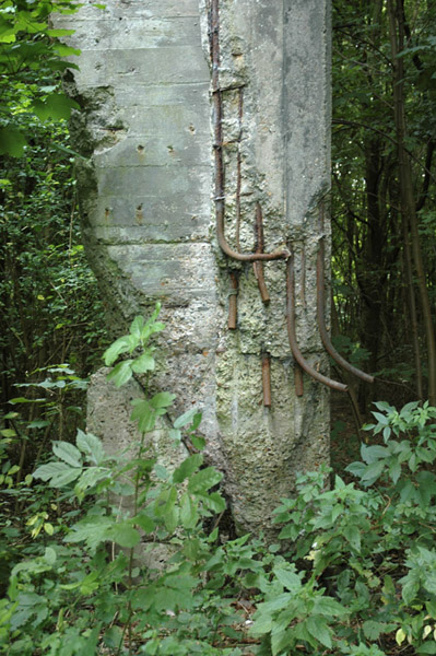
| It was clearly visible that the Germans attempted to blow up this structure when they retreated. The two 'legs' at the back of the photo had explosive charges rigged around them. I guess roughly one meter was blown away, but the legs 'landed' on the 'stumps' so the thing still stands.
|
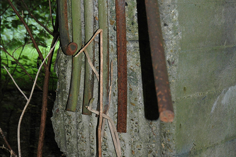
| The rebar of the leg is cut off cleanly, and bent from the blasting. Smooth rebar was (apparently) more commonly used in the past.
| 
|
2016-2018 Google Earth confusion
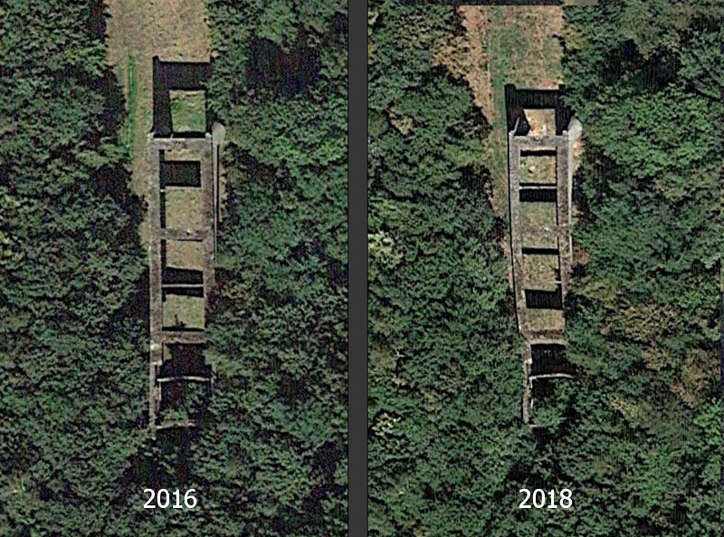
| In Google Earth (the stand-alone version), I noted that between the 2016 and 2018 photos a lot of deformation developed. The formerly straight roof beams now showed a wavy shape. But inspection of the structure in 2024 showed that nothing had happened, it was some sort of lens deformation.
| 
|
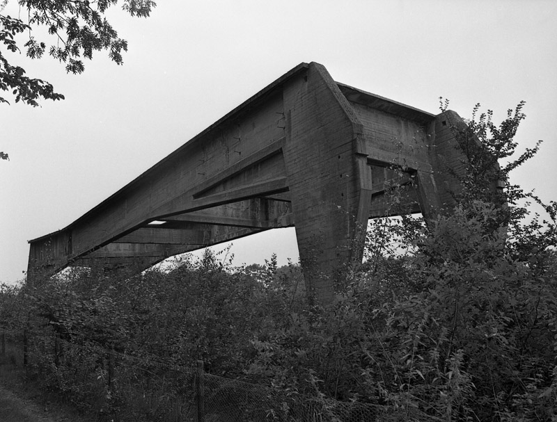
2024 detail photos
| Theo van den Boomen photographed the structure in January 2024. This photo nicely shows how straight the right (west) side of the stucture still is.
| 
|
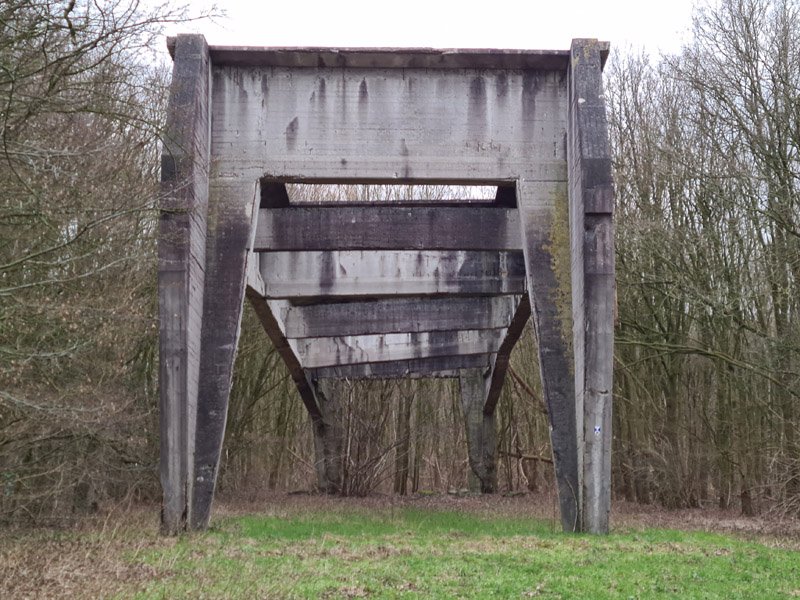
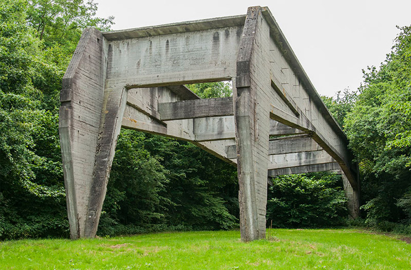
| In this view, the twist in the structure can be seen, caused by the unequal lengths of the 'rear' legs blown out in 1944.
|
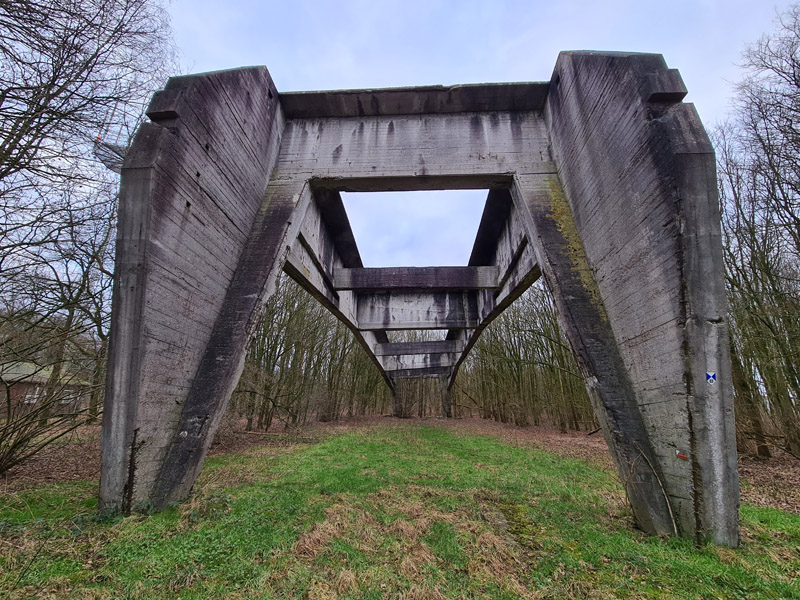
| A short lens photo makes the structure looks even more impressive and bizarre.
| 
|
Guesses
To demonstrate that the structure's strange shape leads to lots of wild guesses, I gathered some comments from the BritModeller forum thread:
"It has a strange shape for an aircraft hangar. Although the structure looks extremely strong, it has no protective roof, or wall, and would therefore not work well as a bunker."
"Maybe it was jet engine test stand. There were a few Ar 234 and Me 262 at Volkel, but for very short periods only."
"An elevated flak position? Is it situated somewhere with a clear view, not withstanding post war vegetation."
Comment: I often read about flak towers on airfields, without having a clue what they looked like. Until I found these photos on the great website of the Nederlands Instituut voor Militaire Historie: Flakstelling op vliegveld Waalhaven, Houten Flaktoren op vliegveld Gilze-Rijen and Op de achtergrond een Flakstelling (vliegveld Eindhoven).
"I think we're looking at just one frameset of multiple intended ones, from the side. Extend/duplicate the existing concrete frame and the construction is very similar to the remaining hangar minus the cladding & roof - the sides being concrete slabs that could be covered with a brick layer to mimic the intended farm building."
"A fixed frame work for bomb handling. Block & tackle fixed on beams (now gone) for lifting bombs on and off trucks and dollies."
Comment: This structure is the one furthest away from the Volkel bomb dump. That bomb dump, just south of Odiliapeel, is another interesting relic, a lot of it is still visible. Most of the bombs and ammo was (apparently) stored in horse-shoe shaped open pits in a wood. The sand that way dug out made a revetment-type wall around it. There are some 70 of these pits still recognisable, it's quite unbelievable when you walk around there, you find one after the other. And if you don't know about it, it just looks like uneven ground. During road works some around 2019, small-gauge tracks were found nearby, that were used for transporting the munitions.
"V2 test and repair facility?"
"This structure looks very like it would have been fitted with gantries for heavy lifting."
"Maybe it is a piece of starting ramp for some Wunderfaffe machine, of course elusive and hidden project?"
"In my opinion with the bent 'roof' it is a foundation for something technical like a radar position or Flakscheinwerfer."
"A technical installation like a Motorprüfstand or radar position is more plausible for me. A Bordwaffentestanlage is also possible."
"It was a project to see if people would wonder what it was some 80 years later.... "
Fliegerhorst Volkel
The Stichting Dutch Starfighter Foundation reports the following, based on work of Traditiekamer Typhoon:
Volkel airbase was built as 'Nachtlandeplatz' in the second half of 1940. In the years that followed, the airfield was expanded into a real 'Fliegerhorst'. To this end, a total of 43 hangars were built at three different locations:
9 T-hangars
1 'stolp'-hangar (maybe similar to a typical 'Stolpboerderij' as built in the province Noord-Holland)
1 arched roof hangar
3 Deisel hangars with 8 truss frames
28 Deisel hangars with 4 truss frames
1 hangar that has not yet been identified
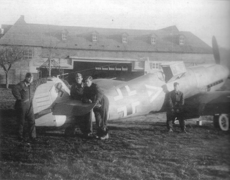
This made the field suitable for receiving the aircraft of a Jagdgeschwader, Nachtjagdgeschwader or Kampfgeschwader, i.e. Bf 109s, FW 190s, Bf 110s or Ju 88s. The T-hangars were so large that an FW 200 would have fit in it.
German maps of Fliegerhorst Volkel
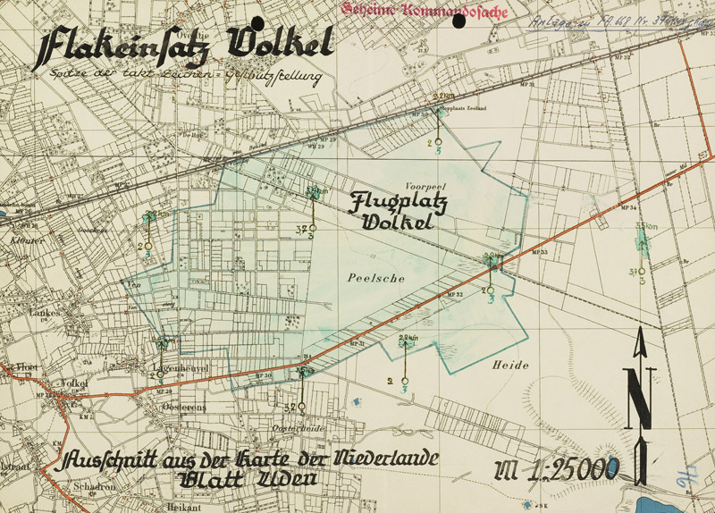
| Equally deep inside the Nederlands Instituut voor Militaire Historie archief I found an online map of Flakeinsatz Volkel (alternate link). Follow the link for a hi-res version. It only shows the outline of the airbase, but even that is new information for me. The set of drawings is dated 22 June 1944, and the airfield has been expanded greatly.
By studying the other maps, I deduced the meaning of the annotations of each flak position. See the full-size map. The bottom number is the number of flak pieces. To the left is the caliber, in centimeters. Above the flak position is the maximum altitude (in kilometers) the flak can reach. The actual position is at the arrow's end, not the circle (at least for the Volkel drawing).
|
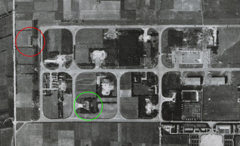
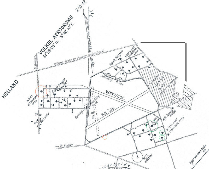
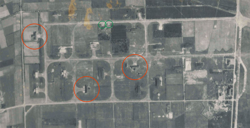
Allied map of Fliegerhorst Volkel
This is the best Allied map of Fliegerhorst Volkel, rotated to true north (not magnetic north).
The object under discussion is circled in red. Circled in green are the other remains: the large circle indicated a still existing hangar ('Deisel' type with eight truss frames, in reinforced concrete, fairly conventional ), and smaller circles indicating two 4-beam Deisel hangars of which small remains are still present.
The map is dated '2-10-42'. But is that October 2nd or February 10th? What date convention did the USAAF use? Anyway, in 1942 all hangars had been built according to this map.
| 
|
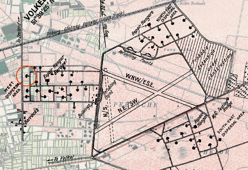
| Here's the same drawing over a 1926 map of the area, the last one made before the war. It can be seen that the 'west dispersal area' was based on the existing road structure. Nearly all land east of that was uncultivated, the northern edge of 'De Peel', a moorland area.
|
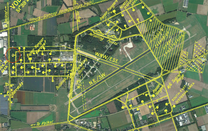
The same overlaid on the 2022 situation, as seen on Google Earth. The 'N.E./S.W.' runway is still in use as the main runway. Part of the W.N.W./E.S.E. runway remains as a flightline. The 'West dispersal area' remains as the center of the airbase, little of the other two dispersal area remains.
Note the amount of vegetation on the 2022 photo. During the war, the area was open and flat, as can be seen in the aerial photos below.
| 
|
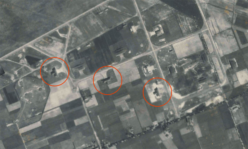
Allied reconaissance photos
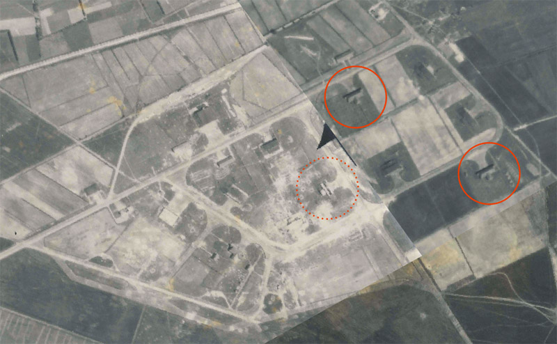
| The 'north-east dispersal area', a cut-out of 20 June 1944, flight 343, run 05, photo 3034. Two T-hangars are easily identified, the third (dotted circle) looks like the third, but with its roof blown off.
This photo appears to show quite a lot of bomb craters. On 8 March 1944, 95 B-26s of the 322nd Bomb Group had hit Volkel. 'Gestaag Gespannen' reports that 820 bombs were dropped, but damage was limited. 12 of 43 hangars were hit, and fire was set to a 50 ton fuel tank. Two similar tanks were pierced and lost their contents.
The description of 12 out of 43 hangars hit fits with the one dispersal area being hit, and it looks like the 'north-east dispersal area' that was hit. Possibly more damage can be spotted in the other two photos, like the lower-right in the photo above.
|
Shape and dimensions
Due to the extension at the rear, to house the rear fuselage and tail planes of a larger aircraft, they were called 'T-hangars' by the allies. They were large enough for a Fw200 or Heinkel 177. The German designation is still unknown.
I used the aerial photo to draw the basic shape of the T-hangars. I measured an overall width of 56 meters, main building width of 49 meters, main building depth of 17 meters, and an extension of 13 meters, making 30 meters total. The aerial photos show clearly that the hangar in question had a 'hip roof' ('Walmdach'), with an extension to the rear with a 'gable roof' ('Satteldach'). Maybe this was done to disguise it as a farm. But being surrounded by classic Deisel hangars makes that a bit silly.
If the skeleton is measured in Google Earth, it's approximately 42 meters in length, and 9 meter wide. Those figures are hard to match with the exterior dimensions of the hangar.
| 
|
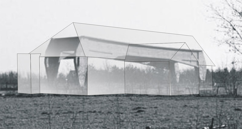
Reconstruction
Based on all of the above, I made a simple 'ghost' drawing of the T-hangar, seen from the rear. I do not know what kind of roof the small side extensions had, so I gave them a flat roof.
Now that we know the outer shape of the T-hangar, I still cannot 'connect' the internal structure with the external shape. And I still cannot understand the massive structure, in combination with non-hardened walls and roof.
Another puzzling aspect is that no-one knows the German name of this hangar type - Germans loved standardisation. Plus: I cannot find pictures of similar structures on other German WW2 airfields.
| 
|
Somewhat similar hangars
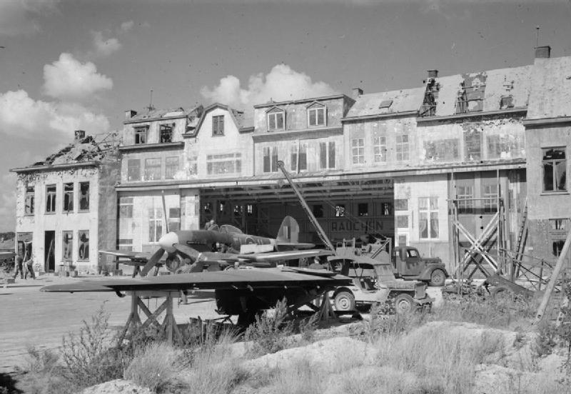
| Wikipedia hangar at Brussel-Melsbroek, suggested by 'Creepy Pete'. The camouflage appears to have been done in Hollywood film set style. The hangar itself has truss beams in the 'long' direction.
|
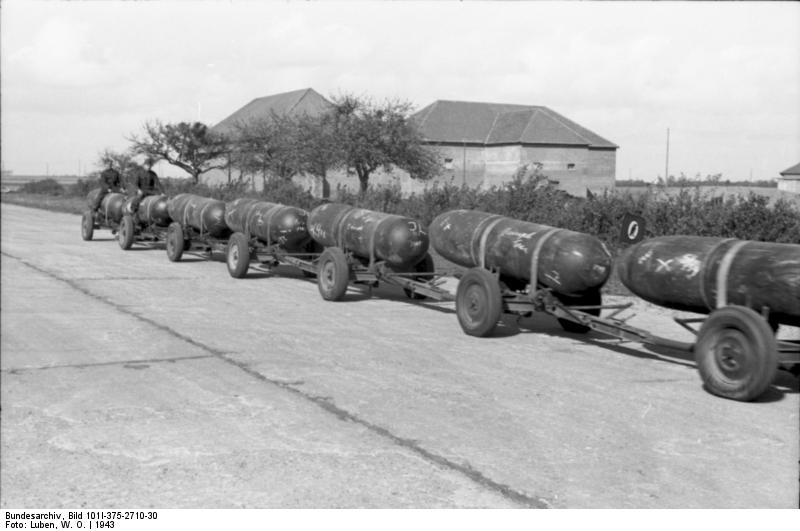
Theo van de Boomen, who's researching the same subject, found an interesting photo on Wikipedia, that shows a hangar of similar layout in the background. Further research led to a 6-page forum thread about Beauvais airfield on the 'Picardie 1939-1945' forum. It identied the three hangars seen in the photo, and shows that remains of all three are still present, just north of the hamlet of Morlaine. I measured a width of around 40 meters, considerably smaller than the 56 meters of the Volkel hangar. Even more important, the photo of the remains shows that these hangars did not have any internal structure resembling that of Volkel.
Source: Bundesarchiv, Bild 101I-375-2710-30, photographer W. O. Luben, CC-BY-SA 3.0, CC BY-SA 3.0 DE, via Wikimedia Commons
| 
|
Questions
After the analysis above, the following questions remain for me:
type, name
mismatch of dimensions of inner and outer structures
how did the exterior structure connect to the inner structure
design philosophy of the structure
Publication
The German magazine 'Jet & Prop' published a question about the Volkel structure, possibly in the October-November 2021 issue, number 4/21. Unfortunately, there were no replies from the readership.
Sources
Return to models page